
Tech Mi Out was established in 2019 with a business focus on providing technology solutions for businesses across industry verticals. Although many of our services are channeled towards the agricultural industry, we also serve other sectors with novel technology solutions. Our services find applications in the mining, construction, agriculture, real estate, and emergency services industries.
Our service is driven by a team of dedicated technology enthusiasts with extensive experience in the areas of their core competence. Our people are open to innovations, allowing us to deploy novel solutions to resolve our client’s challenges. We work closely with technology partners to access top-notch infrastructure to deliver the best possible services to our clients.


We focus on delivering value to our clients, whether we are flying drones, installing sensors for IoT applications, or analysing complicated satellite imagery. That is why we structured our service to integrate seamlessly with our client’s operations. Our goal is to leverage technology to cater to the pressing and emerging needs of the industries we serve.
Within the short time of our corporate existence, we have made a profound impact on the agricultural industry of Malawi. We shall continue to deploy innovation that provides valuable data for enhancing agricultural productivity and promoting sustainable industrial practices.
Our core values are a set of principles that guide our operations and create an enviable benchmark for the quality service we provide.
What services do we provide?
Climate change and depleting soil fertility are factors
undermining the production capacity of farmlands. The high cost of production and the
ever-increasing demand for quality farm produce are putting
farmers under pressure. To mitigate these risks, farmers must
use available resources optimally. Our precision farming service
provides farmers with vital information required to make the
right farm production decisions and to implement sustainable
farming practices.
Our team of experts gives farmers access to the information
required to make data-driven decisions and maximize
productivity. For instance, our soil fertility consultancy
allows farmers to use the right type and quantity of
fertilisers. Our precision farming intervention includes
analysis of macro and trace elements, soil potential,
variability management in fields, water analysis, soil chemical
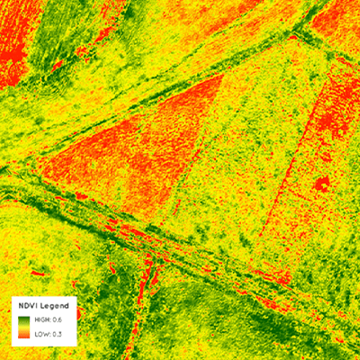
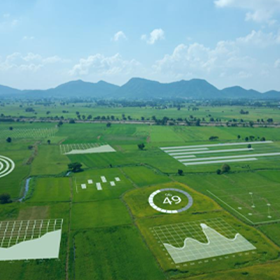
mapping. With use of drones equipped with multispectral cameras,
we are able to provide ability to generate a variety of predefined
and custom index maps.
Our team of experts uses cutting edge drone and satellite
imaging technology to capture image data and convert them to 2D,
3D, and 4D maps. These are delivered to cloud applications that
analyse and interpret them to serve the objectives of our
clients. We use technologies such as LIDAR, Infrared, Orthomosaic mapping and other advanced systems to provide
solutions for our clients. Where there is a need to cover
extensive landmass, we can apply satellite imaging solutions to
deliver high-resolution precision imagery.
With our service, clients can circumvent the expensive route of
hiring aircraft to acquire aerial images. We handle all tasks
ranging from feasibility study, designing a plan for image
acquisition, acquiring images, and extracting intelligence from the
image data. We can also help you integrate imagery into your
business to enhance operations.
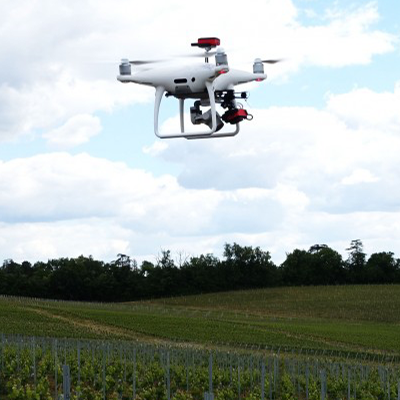
Our drone survey solution provides a cost-efficient avenue for
performing surveys for various industries. Our high-tech drones
use high-resolution cameras and sensors, specially calibrated to
achieve our client's objectives. Our drone survey service can
measure and transmit data that provides valuable insight for
decision making.
Drones are equipped with a multispectral camera. The multispectral
sensor captures the light plants and vegatation reflect in four
separate parts: green and red lights and two infrared bands
invisible to the human eye. Placed on the drone, the sunshine
sensor installed on our drones records the intensity of
light emanating from the sun in these four same bands of light
This technology is useful for measuring distance and volumes,
creating of topographic, hydrographic and thermal maps,
volumetric calculations, and monitoring changes in specific
parameters. It is applicable for viewing heat maps, map
construction sites, and topographic features for mining and
other engineering projects. These are just a few instances of
surveying and mapping, where our drone survey provides value to
clients.
The procedures for performing site surveys and inspections used
to be complicated and time-consuming. However, drone technology
has opened a new frontier by making these processes faster,
highly accurate, and safer than ever. These are the bare minimum
your business can benefit from drone-enhanced site intelligence.
Tech Mi Out offers you much more. Besides creating highly
accurate drone maps, reports, 3D models, and live 2D maps for
construction sites, our platform allows you to extract, store,
and analyse data without any hassle. Your business can also
take advantage of collaboration features for managing your
projects more efficiently.
Our aerial site intelligence solution is excellent for
pre-construction site planning and design, risk analysis,
mapping roof details, pinpointing defects, and much more. Aerial intelligence provides values throughout a project
life cycle, from bidding all through to project delivery. Our
top-notch aerial site intelligence provides precision data that
helps you execute your projects safely, on schedule, and on
budget.
Our IoT solution allows clients to use the latest technology to
gather vital real-time information about their operations. In
contrast to the stereotyped machines used in conventional
industries, IoT enabled devices are smart machines. They
communicate with the environment through integrated sensors and
receptors. Depending on the design, the data could be
transferred to a database or programmed to trigger specific
actions based on the data it gathers.
With our IoT solution, industrial automation is elevated to make
virtually everything smart and intelligible. Electronic devices can now learn from their environment and
perform actions with minimal human interference. Our IoT
solution deploys various solutions across industry verticals.
Some of these include preventative maintenance, multiple device
audit, performance monitoring, QoS, proactive security, and much
more.
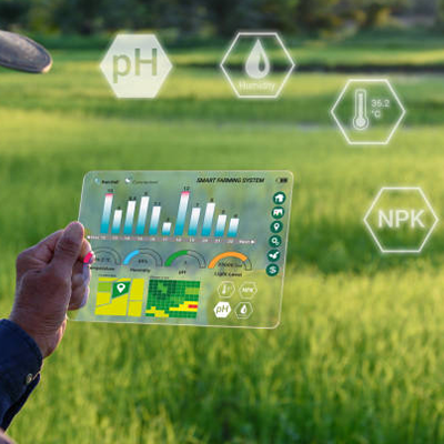
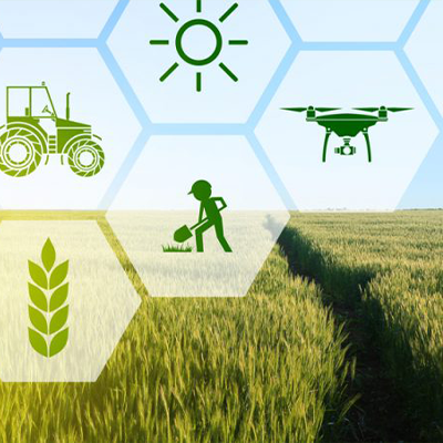
Modern farmers leverage technology and analytics to gain
insights into farm field operations. That is why
technology-enhanced farming enjoys better yield and financial
performance. Unfortunately, most farms in Malawi still use
traditional farming techniques because they lack access to the
latest information and technology. However, our service is now
making this technology available and affordable to farmers in
Malawi.
Our Agtech service is aimed at helping farmers leverage insight
from data to minimise expenditure, optimise yield, increase
revenue, and mitigate crop failure. We use technologies such as
the Internet of Things, big data analytics, and visualisation
capabilities to help farmers make data-driven decisions. Such
smart decisions lead to increased productivity and
profitability. Whether it is poultry, fish farming, or crop
production, our service help farmers increase the overall
profitability of their business.
An overview of our current projects

Our intervention was required due to heavy losses incurred by the client poultry business. Pitfalls include human error (poor response to local alarm) and lack of historical data for business intelligence. We deployed a system for monitoring critical aspects of the poultry, including hatchery, layer, and broiler sections. At completion, the client was able to monitor sections remotely, receive real-time alerts, and automate actions.
This project involves the use of drone technology, data analytics, and machine learning to improve crop performance. Farmers can access valuable data through our web and mobile application interface. Our project helped farmers in Macadamia improve production, profits, and sustainability. Presently, our drone survey services focus on Orchard Management, Problem Tree Identification, Pest & Disease Management and Yield Management.

We leverage satellite and drone imagery to provide a platform to enable growers to determine areas of possible theft, poor growth, and healthy yields.
To develop home-grown technology that allows Malawi to provide expertise and technology to foreign countries.


We understand how important providing safe and consistent water supply to under privileged areas is. From our research, we found that the majority of population using boreholes to access safe water live in rural areas. Hand pumps are the preferred technology, as they can provide wide access to good quality groundwater at low cost. However, up to one third of hand pumps do not function at any one time, with many abandoned by their communities. Recent studies finds the cost of repairs, time taken to carry out repairs and frequency of breakdown to be leading factors for frustrations experienced with hand pumps. Tech Mi Out is currently in product development around the use of remote sensors and mobile technology to monitor use and functionality of hand pumps to potential problems in real-time to determine and alert use of:
The purpose of our services is to achieve the following goals
To promote sustainability by implementing the technology that optimises the use of resources while maximising production.
To add value to industries that help increases production, enhance the nation’s GDP, and provide employment.
Increase the efficiency of our client assets and operational procedures to improve overall productivity.
Provide the technology that helps clients reduce wastage, to cut down their operational costs.
To develop home-grown technology that allows Malawi to provide expertise and technology to foreign countries.
Our overall impact is to cut costs and increase production as well as enhance the bottom line of our clients.
Feel free to get in contact with us for any questions and/or queries.
PO BOX 434, Blantyre,
Malawi
+265 9999 61 233
hello@techmiout.com
 Integrity
 Leadership
 Customer-Oriented Services
 Result-Oriented Services
 Relationship
 Innovation